In an earlier blog post, we looked at maps drawn by students and alumnae of The Woman’s College of the University of North Carolina (now UNCG). In this blog post, we’ll look at some more diverse campus maps found within our collections!
Changes on campus can be traced by maps that show the university’s relationship to the community and transportation. The following two parking maps show the growth of the campus and the increase in parking areas on campus.
 |
| 1975 Campus Parking Map |
It is also interesting to note that many former roads that cut through campus are now restricted and used primarily as pedestrian walkways- an example of changing campus policy in action reflected on maps!
 |
| 2006-2007 Campus Parking Map |
The need for parking maps at school with a large commuter population is obvious and it’s important for those maps to be accurate. But we also have maps that are more fanciful and even metaphorical!
The map featured on the 1948 Pine Needles Yearbook endpapers contains a reasonable facsimile of campus at the time, but notice the scale used. “Four Years Equals One Degree” The first clue that this map may be a little more tongue-in-cheek than others is that it is labeled “A Curry Smoke-Stack View of Campus.” There is, in fact, a student standing on the smoke stack with a spyglass, surveying the school. Fanciful descriptions are also used alongside typical names you might find on any campus map. The cars in front of Foust are labelled “Faculty Jalopies.” An area near the athetic fields is labelled “W.C.’s Coney Island” and the area behind Weil-Winfield is labelled “The Country Club.”
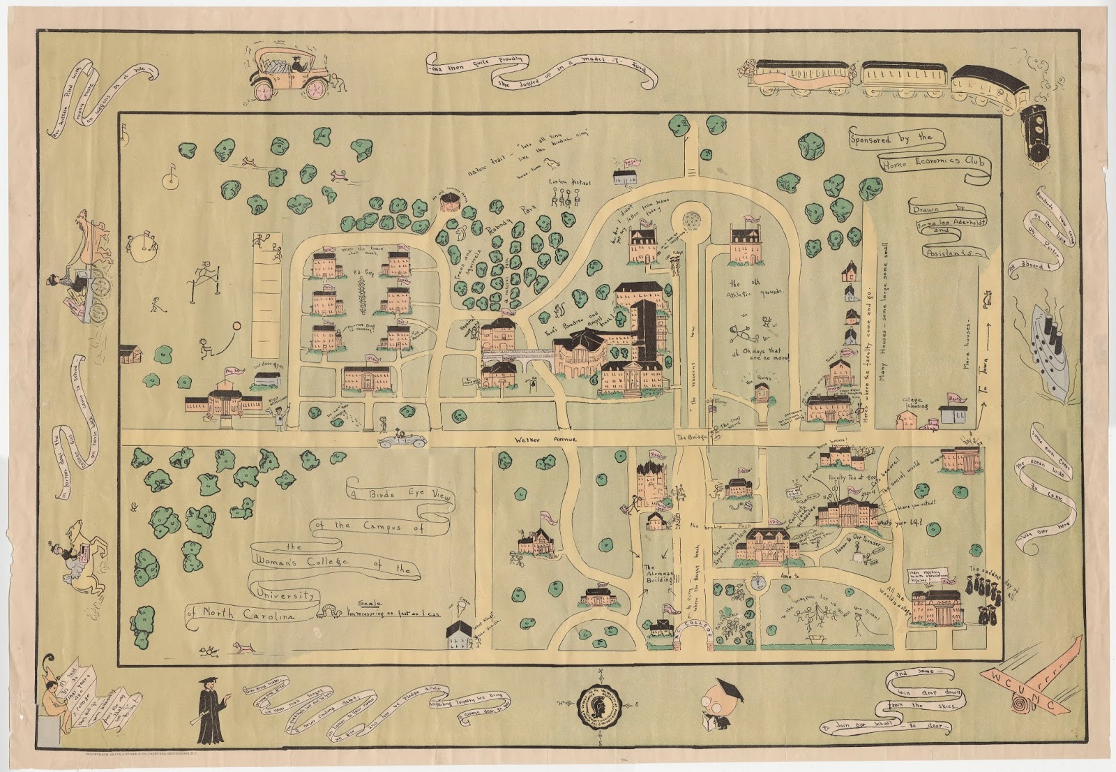
This whimsical map dating from around 1935 was drawn by Emma Lee Aderholt and sponsored by the Home Economics Club. It not only shows the buildings and grounds of the campus at the time, but also includes many clues as to campus activities. You will find the Botany class in front of the Foust Building (marked “Admin” on this map), as well as a depiction of some of the May Day activities. In front of Old McIver Memorial Building, you can just make out a “Freshie” (freshman student) washing the statue of Charles D. McIver. There is a P.J. party taking place in Peabody Park. UNCG Auditorium (Aycock Auditorium at that time) is the site of “The Saddest Day of All”- Graduation Day.

Not all maps represent actual physical places. “The Pscientist’s Progress” is a map that appeared in the 1911 Carolinian yearbook. This student drawn map shows the perilous journey of those brave students who ventured onto the path of Bachelor of Science degrees at the school. Courses and subjects are presented as dangerous milestones that must be transcended to achieve the student’s final destination-their degree.
By Scott Hinshaw
2 replies on “Campus Maps Part II”
This is fantastic. I am the GIS/Cartographer with FDC here at UNCG and Would love to explore these maps in more detail. I had a few old campus maps set up during the campus business expo and wish I knew about some of these. Who should I contact over there in archives?
We would love to show you these maps! You can email us at SCUA@uncg.edu to set a time to come over to look at them. We're open M-F between 9am and 5pm.